Vegetables to Plant in Canada
Scroll to Map & DescriptionsSelect your Climatic Region in Canada
Zone 2a Zone 2b Zone 3a Zone 3b Zone 4a Zone 4b Zone 5a Zone 5b Zone 6a Zone 6b Zone 7a Zone 7b Zone 8a Zone 8b Zone 9aSelect your City or Town Nearby
If you cannot find your town, try this link Plant Hardiness Zone by Municipality
- Abbotsford
- Acton
- Acton Vale
- Airdrie
- Aldergrove
- Aldergrove East
- Alexandria
- Alliston
- Alma
- Almonte
- Altona
- Amherst
- Amherstburg
- Amos
- Amqui
- Angus–Borden
- Antigonish
- Armstrong
- Arthur
- Asbestos
- Assiniboia
- Atikokan
- Aylmer
- Ayr
- Baie-Comeau
- Baie-Saint-Paul
- Banff
- Barrhead
- Barrie
- Bathurst
- Bay Roberts
- Beamsville
- Beauceville
- Beaumont
- Beausejour
- Beaverlodge
- Beaverton
- Bedford
- Belleville
- Beloeil
- Berthierville
- Berwick
- Biggar
- Binbrook
- Bishop's Falls
- Black Diamond
- Blackfalds
- Blenheim
- Blind River
- Bobcaygeon
- Bolton
- Bonavista
- Bonnyville
- Botwood
- Bouctouche
- Bowmanville
- Bracebridge
- Bradford
- Brandon
- Brantford
- Bridgenorth–Chemong Park
- Bridgewater
- Brighton
- Brockville
- Brooks
- Brownsburg
- Buckingham
- Cabano
- Caledon
- Caledonia
- Calgary
- Campbell River
- Campbellford
- Campbellton
- Campbellton
- Camrose
- Canmore
- Cannington
- Canora
- Capreol
- Caraquet
- Carbonear
- Cardston
- Carleton Place
- Carlisle
- Carman
- Carstairs
- Casselman
- Castlegar
- Causapscal
- Chandler
- Chase
- Châteauguay
- Chatham - Douglastown
- Chatham-Kent
- Chelmsford
- Chemainus
- Chesley
- Chestermere
- Chibougamau
- Chicoutimi - Jonquière
- Chilliwack
- Chippawa
- Clarenville-Shoal Harbour
- Claresholm
- Clermont
- Clinton
- Coaldale
- Coalhurst
- Coaticook
- Cobble Hill
- Cobourg
- Cochrane
- Cochrane
- Colchester
- Cold Lake
- Collingwood
- Constance Bay
- Contrecoeur
- Corner Brook
- Cornwall
- Corunna
- Courtenay
- Cowansville
- Cowichan Bay
- Crabtree
- Cranbrook
- Creston
- Crossfield
- Crystal Beach
- Cumberland
- Dalhousie
- Dalmeny
- Danville
- Dauphin
- Dawson Creek
- Deep River
- Deer Lake
- Delhi
- Devon
- Didsbury
- Digby
- Disraeli
- Dolbeau
- Donnacona
- Dorchester
- Drayton
- Drayton Valley
- Dresden
- Drumheller
- Drummondville
- Dryden
- Duncan
- Dundalk
- Dunnville
- Durham
- East Angus
- East Broughton
- Edmonton
- Edmundston
- Edson
- Elliot Lake
- Elmira
- Elmvale
- Embrun
- Enderby
- Enfield
- Erin
- Espanola
- Essex
- Esterhazy
- Estevan
- Exeter
- Fairview
- Farnham
- Fenelon Falls
- Fergus
- Ferme-Neuve
- Fernie
- Filion
- Flin Flon (Manitoba part)
- Forest
- Forestville
- Fort Erie
- Fort Frances
- Fort Macleod
- Fort McMurray
- Fort Nelson
- Fort Qu'Appelle
- Fort Saskatchewan
- Fort St. John
- Fort-Coulonge
- Frankford
- Fredericton
- Gananoque
- Gander
- Gaspé
- Gentilly
- Georgetown
- Geraldton
- Gibbons
- Gibsons
- Glencoe
- Goderich
- Golden
- Granby
- Grand Bank
- Grand Bend
- Grand Falls / Grand-Sault
- Grand Falls-Windsor
- Grand Forks
- Grande Cache
- Grande Prairie
- Gravenhurst
- Grimshaw
- Guelph
- Hagersville
- Haileybury
- Halifax
- Hamilton
- Hampton
- Hanna
- Hanover
- Happy Valley-Goose Bay
- Harriston
- Harrow
- Havre-Saint-Pierre
- Hawkesbury
- Hearst
- High Level
- High Prairie
- High River
- Hinton
- Hope
- Houston
- Hudson
- Humboldt
- Huntingdon
- Huntsville
- Ilderton
- Indian Head
- Ingersoll
- Innisfail
- Innisfil
- Invermere
- Iroquois Falls
- Jasper
- Joliette
- Kamloops
- Kamsack
- Kanata
- Kapuskasing
- Kelowna
- Kemptville
- Kenora
- Kent
- Kentville
- Keswick–Elmhurst Beach
- Killarney
- Kimberley
- Kincardine
- Kindersley
- King
- Kingston
- Kingston - Greenwood
- Kirkland Lake
- Kitchener
- Kitimat
- L'Annonciation
- L'Assomption
- La Malbaie
- La Pocatière
- La Ronge
- La Sarre
- La Tuque
- Lac la Biche
- Lac-Etchemin
- Lac-Mégantic
- Lachute
- Lacombe
- Ladner
- Ladysmith
- Lake Cowichan
- Lake Echo
- Lakefield
- Langdon
- Laurier-Station
- Lavaltrie
- Leamington
- Lebel-sur-Quévillon
- Leduc
- Lethbridge
- Lewisporte
- Limoges
- Lindsay
- Listowel
- Liverpool
- Lloydminster
- Lloydminster
- London
- Louiseville
- Lucan
- Lumsden
- Lunenburg
- Mackenzie
- Magog
- Magrath
- Malartic
- Maniwaki
- Manotick Station
- Maple Creek
- Marathon
- Marieville
- Martensville
- Marystown
- Matane
- Mattawa
- McGregor
- Meadow Lake
- Meaford
- Medicine Hat
- Melfort
- Melville
- Merritt
- Middleton
- Midland
- Milton
- Minnedosa
- Mission
- Mississauga Beach
- Mistissini
- Mitchell
- Moncton
- Mont-Joli
- Mont-Laurier
- Montmagny
- Montréal
- Moose Jaw
- Moosomin
- Morden
- Morinville
- Morrisburg
- Mount Albert
- Mount Brydges
- Mount Forest
- Nanaimo
- Napanee
- Napierville
- Neepawa
- Nelson
- New Glasgow
- New Hamburg
- New Liskeard
- Newcastle
- Nicolet
- Nipawin
- Niverville
- Nobleton
- Normandin
- North Battleford
- North Bay
- Norwich
- Oakbank
- Okanagan Falls
- Okotoks
- Olds
- Oliver
- Orangeville
- Orillia
- Oromocto
- Osgoode
- Oshawa
- Osoyoos
- Ottawa–Gatineau
- Outlook
- Owen Sound
- Palmerston
- Paris
- Parksville
- Parry Sound
- Pasadena
- Peace River
- Peachland
- Pelican Narrows
- Pembroke
- Penhold
- Penticton
- Perth
- Perth-Andover
- Petawawa
- Peterborough
- Petrolia
- Picton
- Pictou
- Pierreville
- Pincher Creek
- Placentia
- Plessisville
- Ponoka
- Pont-Rouge
- Port Alberni
- Port Colborne
- Port Dover
- Port Elgin
- Port Hardy
- Port Hawkesbury
- Port Hope
- Port McNeill
- Port Perry
- Port Stanley
- Port-Cartier
- Portage la Prairie
- Portneuf
- Powell River
- Prescott
- Prince Albert
- Prince Edward
- Prince George
- Prince Rupert
- Princeton
- Princeville
- Québec
- Quesnel
- Rawdon
- Raymond
- Red Deer
- Redcliff
- Regina
- Regina Beach
- Renfrew
- Revelstoke
- Richmond
- Richmond
- Ridgetown
- Rigaud
- Rimbey
- Rimouski
- Rivière-du-Loup
- Roberval
- Rockland
- Rockwood
- Rocky Mountain House
- Rosetown
- Rossland
- Rouyn-Noranda
- Roxton Pond
- Russell
- Sackville
- Saint Andrews
- Saint John
- Saint-Agapit
- Saint-Alexis-des-Monts
- Saint-Ambroise
- Saint-André-Avellin
- Saint-Anselme
- Saint-Apollinaire
- Saint-Augustin
- Saint-Bruno
- Saint-Félicien
- Saint-Georges
- Saint-Germain-de-Grantham
- Saint-Honoré
- Saint-Hyacinthe
- Saint-Jacques
- Saint-Jean-Port-Joli
- Saint-Jean-sur-Richelieu
- Saint-Joseph-de-Beauce
- Saint-Jovite
- Saint-Marc-des-Carrières
- Saint-Pascal
- Saint-Pie
- Saint-Prosper
- Saint-Quentin
- Saint-Raymond
- Saint-Rémi
- Saint-Sauveur-des-Monts
- Saint-Tite
- Sainte-Adèle
- Sainte-Agathe-des-Monts
- Sainte-Anne-des-Monts
- Sainte-Anne-des-Plaines
- Sainte-Claire
- Sainte-Madeleine
- Sainte-Marie
- Sainte-Martine
- Salaberry-de-Valleyfield
- Salisbury
- Salmon Arm
- Sarnia
- Saskatoon
- Sault Ste. Marie
- Schomberg
- Seaforth
- Sechelt
- Selkirk
- Senneterre
- Sept-Îles
- Sexsmith
- Shaunavon
- Shawinigan
- Shawnigan-Mill Bay
- Shediac
- Shelburne
- Shelburne
- Sherbrooke
- Simcoe
- Sioux Lookout
- Slave Lake
- Smithers
- Smiths Falls
- Smithville
- Sooke
- Sorel
- Southampton
- Sparwood
- Springdale
- Springhill
- Spruce Grove
- Squamish
- St. Anthony
- St. Catharines–Niagara
- St. Jacobs
- St. John's
- St. Marys
- St. Paul
- St. Stephen
- St. Thomas
- Stanley Mission
- Stayner
- Steinbach
- Stephenville
- Stettler
- Stirling
- Stonewall
- Stony Plain
- Stouffville
- Stratford
- Strathmore
- Strathroy
- Sturgeon Falls
- Sudbury
- Summerland
- Sussex
- Sutton
- Swan River
- Swift Current
- Sylvan Lake
- Taber
- Tavistock
- Terrace
- Thamesford
- The Pas
- Thetford Mines
- Thornbury
- Three Hills
- Thunder Bay
- Thurso
- Tilbury
- Tillsonburg
- Timmins
- Tisdale
- Toronto
- Tracadie-Sheila
- Trois-Pistoles
- Trois-Rivières
- Truro
- Turner Valley
- Uxbridge
- Val-d'Or
- Val-David
- Valcourt
- Vancouver
- Varennes
- Vegreville
- Verchères
- Vermilion
- Vernon
- Victoriaville
- Ville-Marie
- Vineland
- Virden
- Wainwright
- Walkerton
- Wallaceburg
- Warman
- Warwick
- Wasaga Beach
- Waterford
- Waterloo
- Watrous
- Wawa
- Welland–Pelham
- Wellesley
- Westlock
- Wetaskiwin
- Weyburn
- Wheatley
- Whistler
- White City
- White Rock
- Whitecourt
- Wiarton
- Williams Lake
- Winchester
- Windsor
- Windsor
- Windsor
- Wingham
- Winkler
- Winnipeg
- Wolfville
- Woodstock
- Woodstock
- Wynyard
- Wyoming
- Yarmouth
- Yorkton
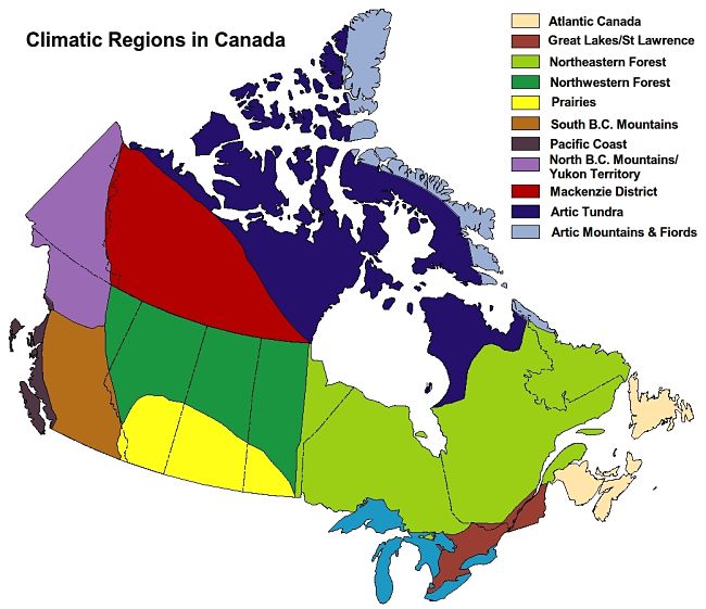
Canada Climate Zone Map
The map below shows the general climate regions in Canada
Canada Hardiness Zones
The map below shows the latest version of the Canada Hardiness Zones
The new classifications used a wide range of climate information rather than minimum annual temperatures. It included information such as:
- annual mean temperature
- maximum temperature of warmest month
- minimum temperature of coldest month
- annual precipitation
- precipitation of warmest month
- precipitation of coldest month
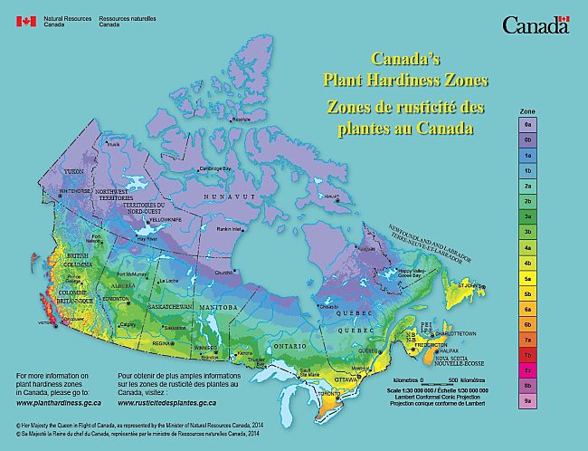
For four more detailed hardiness maps see Hardiness Regional Maps
Hardiness Zone Classification Based on Minimum Temperature
Temperature scales used to define USDA hardiness zones are the mean annual extreme minimums (that is the lowest temperature recorded there in a given year). The USDA uses temperature data from various sites, averaged over a range of years.
| Canada Zones | From | To |
| 0a | < −53.9 °C (−65 °F) | |
| 0b | −53.9 °C (−65 °F) | −51.1 °C (−60 °F) |
| 1a | −51.1 °C (−60 °F) | −48.3 °C (−55 °F) |
| 1b | −48.3 °C (−55 °F) | −45.6 °C (−50 °F) |
| 2a | −45.6 °C (−50 °F) | −42.8 °C (−45 °F) |
| 2b | −42.8 °C (−45 °F) | −40 °C (−40 °F) |
| 3a | −40 °C (−40 °F) | −37.2 °C (−35 °F) |
| 3b | −37.2 °C (−35 °F) | −34.4 °C (−30 °F) |
| 4a | −34.4 °C (−30 °F) | −31.7 °C (−25 °F) |
| 4b | −31.7 °C (−25 °F) | −28.9 °C (−20 °F) |
| 5a | −28.9 °C (−20 °F) | −26.1 °C (−15 °F) |
| 5b | −26.1 °C (−15 °F) | −23.3 °C (−10 °F) |
| 6a | −23.3 °C (−10 °F) | −20.6 °C (−5 °F) |
| 6b | −20.6 °C (−5 °F) | −17.8 °C (0 °F) |
| 7a | −17.8 °C (0 °F) | −15 °C (5 °F) |
| 7b | −15 °C (5 °F) | −12.2 °C (10 °F) |
| 8a | −12.2 °C (10 °F) | −9.4 °C (15 °F) |
| 8b | −9.4 °C (15 °F) | −6.7 °C (20 °F) |
| 9a | −6.7 °C (20 °F) | −3.9 °C (25 °F) |
| 9b | −3.9 °C (25 °F) | −1.1 °C (30 °F) |
| 10a | −1.1 °C (30 °F) | +1.7 °C (35 °F) |
| 10b | +1.7 °C (35 °F) | +4.4 °C (40 °F) |
| 11a | +4.4 °C (40 °F) | +7.2 °C (45 °F) |
| 11b | +7.2 °C (45 °F) | +10 °C (50 °F) |
| 12a | +10 °C (50 °F) | +12.8 °C (55 °F) |
| 12b | > +12.8 °C (55 °F) |
Canada Climate Zone Descriptions
Canada Zone 2a - Sub Arctic
Extreme Minimum Temperate −45.6 to −42.8°C (−50 to −45°F)
This region has a humid continental climate (Köppen climate classification Dfb), just above a subarctic climate. It features cool summers, very cold winters and high rainfall or snow for most of the year (peaking in July to September).
Towns include: Amos, Chibougamau, Hearst, High Level, La Sarre.
Canada Zone 2b - Sub Arctic
Extreme Minimum Temperate −42.8 to −40.0°C (−45 to −40°F)
This climate zone is transitional between the subarctic and humid continental climate zones. There are long, very cold and dry winters. The summer growing season is very short, with frequent frosts.
Towns include: Pelican Narrows, Cochrane, Dolbeau, Normandin, Kapuskasing.
Canada Zone 3a - Temperate Short Cool Summer
Extreme Minimum Temperate −40.0 to −37.2°C (−40 to −35°F)
This zone has a humid continental, near subarctic climate, (Köppen : Dfc). The climate features short cool summers and cold winters with snow. Average rainfall is moderate, generally in the summer months. Most snow falls between October and April.
Towns include:Fort McMurray, Swan River, Bonnyville, Canora, Banff.
Canada Zone 3b - Temperate Short Cool Summer
Extreme Minimum Temperate −37.2 to −34.4°C (−35 to −30°F)
This region has a humid continental climate (Köppen climate classification Dfb) with short cool summers and very cold freezing, windy, winters.
Towns include: Edmonton, Saskatoon, Regina, Chicoutimi - Jonquière, Thunder Bay, Grande Prairie.
Canada Zone 4a - Temperate Mild Summer
Extreme Minimum Temperate −34.4 to −31.7°C (−30 to −25°F)
This region has a humid continental climate (Köppen climate classification Dwb), with snowy, cold winters, but with warm summers.
Towns include: Calgary, Winnipeg, Red Deer, Spruce Grove, Dalhousie, Fort Macleod
Canada Zone 4b - Temperate Mild Summer
Extreme Minimum Temperate −31.7 to −28.9°C (−25 to −20°F)
This zone has a mild, warm summer, Mediterranean climate (Köppen Csb). It has cool, rainy winters and generally dry and sunny summers. During the winter, the average daily high and low temperatures are 8 and 4°C (46.4 and 39.2°F), respectively. The summer months are also relatively mild, with an average high temperature of 20°C (68°F) and low of 11°C (51.8°F).
Towns include: Victoria, Sudbury, Lethbridge, Medicine Hat, North Bay, Campbellton, East Broughton.
Canada Zone 5a - Temperate Mild Summer
Extreme Minimum Temperate −28.9 to −26.1°C (−20 to −15°F)
This zone has a humid continental climate (Köppen Dfb), with long, cold, and snowy winters, warm summers. There are short, generally cool or mild springs and autumns. Rainfall is moderate: highest in summer and fall and lowest from January to April.
Towns include: Sherbrooke, Trois-Rivières, Drummondville, Sault Ste. Marie, Prince George.
Canada Zone 5b - Temperate Mild Summer
Extreme Minimum Temperate −26.1 to −23.3°C (−15 to −10°F)
This region has a sunny humid continental climate (Köppen Dfb) with four distinct seasons. Snow and ice are dominant during the winter season. Spring and fall vary considerably from year to year, prone to frosts and sudden changes in conditions. Summers are warm, occasionally hot. Rainfall is moderate.
Towns include: Ottawa, Barrie, Guelph, Kanata, Moncton, Peterborough, Fredericton.
Canada Zone 6a - Temperate Warm Summer
Extreme Minimum Temperate −23.3 to −20.6°C (−10 to −5°F)
This zone has a humid continental climate (Köppen Dfa/Dfb).Summers are generally humid and warm. Winters are freezing, snowy, and windy. Daily average winter temperatures generally range from −10.5 to −9 degrees C (13 to 16 degrees F) in January. Early and late season snow storms can occur in November and March. Many areas are snow free from late April to late October. Annual rainfall is moderate to high.
Towns include: Montréal, Oshawa, Windsor, St. John's, Kingston, Milton, Brantford
Canada Zone 6b - Temperate Warm Summer
Extreme Minimum Temperate −20.6 to −17.8°C (−5 to 0°F)
The climate in this region is humid-continental, with changeable weather patterns (Köppen Dfb/Dfa). In many areas there are large seasonal contrasts. The summers are usually warm to hot and humid, with a July average around 20 degrees C (70 degrees F). Temperatures above 30 degrees C (85 degrees F) occur for 10 days or more in most years. Winters are relatively mild. Spring is often wet and cool.
Towns include: Hamilton, London, Halifax, Sarnia, Welland–Pelham, Dresden, Dunnville.
Canada Zone 7a - Temperate Hot Summer, Mild Winter
Extreme Minimum Temperate −17.8 to −15.0°C (0 to 5°F)
This zone features hot and humid summers and cold winters. It has a humid continental climate (Köppen : Dfa). There are generally four distinct seasons and generally low diurnal temperature range. Winters are generally cold with frequent snowfall. Towns such as Toronto on the shores of Lake Ontario, are warmer in winter and cooler in summer than in other areas.
Towns include: Toronto, Essex, St. Catharines–Niagara, Kelowna, Colchester.
Canada Zone 7b - Temperate Hot Summer, Mild Winter
Extreme Minimum Temperate −15.0 to −12.2°C (5 to 10°F)
This zone has a generally mild climate year round with occasional extended periods of rainfall. The climate is classified as a marine west coast oceanic climate. Winters are quite mild, though cool and damp, with occasional cold snaps.
Towns include: Kitimat, Nelson, Port Alberni, Port Hardy, Port McNeill, Prince Rupert.
Canada Zone 8a - Temperate Year Round
Extreme Minimum Temperate −12.2 to −9.4°C (10 to 15°F)
This zone is located only on the southern coast of British Columbia. It features has a temperate climate with mild, rainy, winters and cool dry summers. It is generally described as a cool-summer Mediterranean zone (Köppen Csb). Heavy snowfall can occasionally occur during winter.
Towns include: Nanaimo, Cobble Hill, Cowichan Bay, Duncan, Ladner.
Canada Zone 8b - Temperate Year Round
Extreme Minimum Temperate −9.4 to −6.7°C (15 to 20°F)
This zone has a mild, temperate climate classified as oceanic or marine west coast (Köppen Cfb). Rainfall is generally high. On average, snow falls occur on 7-10 days per year. Winters are very mild. Growing season averages around 200-250 days, extending from March until November.
Towns include: Vancouver, Abbotsford, White Rock, Chilliwack, Mission, Sechelt, Sooke.
Canada Zone 9a - Temperate Year Round
Extreme Minimum Temperate −6.7 to −3.9°C (20 to 25°F)
This is the warmest zone in Canada. It features a temperate coastal climate (Köppen : Csb), with mild, rainy winters and warm, dry summers.
Towns include: Gibsons, Powell River.
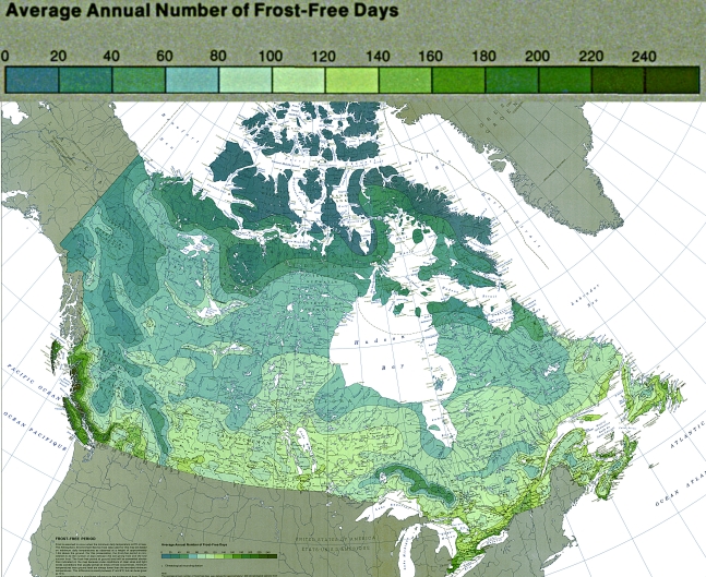
Frost Free Days in Canadian Regions
For original maps see Canada Frost Free Days Map - National Atlas of Canada
Disclaimer: The PlantWhatWhen vegetable planting guide is only designed for use as a very general reference for home gardening purposes. It is not to be used for farming, markets or commercial activities of any kind whatsoever. We take absolutely no responsibility for the accuracy and adequacy of the information provided on this site. We recommend that you consider your local climate, weather patterns and conditions when deciding what and when to plant in your home garden. It's entirely your own decision. Happy Gardening and Best Wishes!